

The Precinct-Preserving Splitline Procedure (PPS)

Roy Minet November 18, 2022
Suppose it were possible to write down a clear and concise procedure to define electoral districts that is guaranteed to be completely impartial. Such a procedure could be followed by anyone, or even a computer, and the identical impartially drawn districts would be the result. And suppose that same straightforward procedure could be used to quickly and impartially draw equal-population districts very accurately for any number of districts and for any state. The procedure could be enshrined in the Constitution and there would be no need to re-invent the “redistricting wheel” every ten years. Redistricting could be done quickly, at very low cost and without all the strife. The process would be completely transparent and anyone could verify that districts have been correctly drawn.
The good news is that such a procedure has already been written down and is available for use at any time. It is called the Precinct-Preserving Splitline procedure or PPS. It has just 5 steps. It will never divide voting precincts and always produces equal-population districts which are maximally compact. Here is the PPS procedure:
Precinct-Preserving Splitline Procedure
For Defining Electoral Districts
In all cases where a political entity (e.g., a state) is entitled to elect multiple representatives, the procedure defined here must be used to determine the electoral districts for such representatives. Voting precincts will never be divided. The geographic boundaries of political entities (States, Counties, Municipalities and Precincts) and the total populations for each precinct are the only data to be utilized.
If the population of the political entity is p and the number of districts to be drawn is n, the following (sometimes iterative) procedure is to be used.
1. If n is 1, no subdivision is necessary and this is a final district. If n > 1, then define two new numbers i = n/2 rounded up and j = n/2 rounded down. (Note that i + j always equals n, and if n is even, i obviously will equal j.)
2. Draw the shortest possible (great circle) line dividing the area into two sections so that one section has a population equal to p multiplied by i/n, while the population of the other section has a population equal to p multiplied by j/n. If there is more than one equally short line, use the line closest to a north-south orientation and if there is still a tie, use the westernmost line. For irregularly shaped entities, it is possible that a line could exit and then re-enter the entity; the length of the line is defined to be the total distance between the two most distant points of intersection which lie on the boundary of the area being subdivided.
3. Make a list of just the voting precincts which have parts of their area on both sides of the great circle line just drawn. If 80% or more of any split precinct’s area lies on one side of the line, assign each such precinct to that same side of the line and remove it from the list. Sort the remaining list in the order of the largest population precinct to the smallest population precinct.
4. If there are any precincts on the list, assign the first (largest) to the side of the line which needs the most people to hit its population target. Repeat this step until all precincts have been assigned.
5. The division of the original large area into two sections has now been completely defined. For each of the resulting two sections separately, go back to step 1 using the section’s population for p and either i or j (whichever was associated with the section) as n.
——— End of Procedure ———
Those not mathematically inclined will prefer to have a visual illustration of how the procedure works. We will utilize the state of Pennsylvania for such an example.
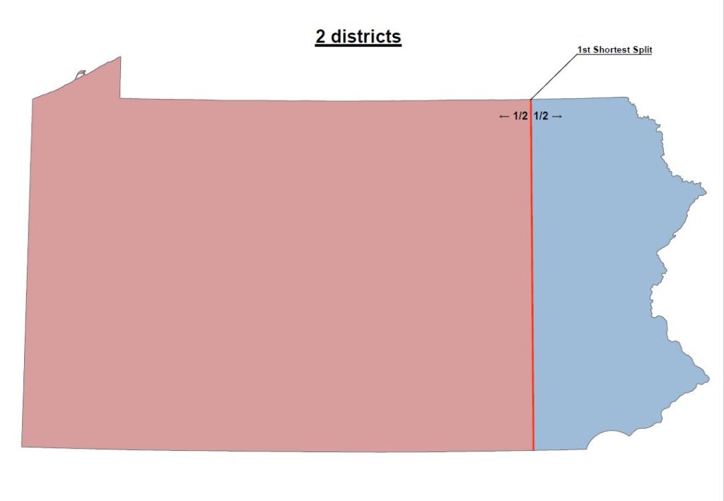
If PA had just one representative, there would obviously be nothing to do and the entire state would be the one required district. The map below shows PA with two districts. The procedure draws them simply by finding the shortest possible line that divides the state into two sections, each having ½ the population. Nothing could be simpler or more impartial. If that line splits any voting precincts, a simple rule determines on which side of the line each split precinct is to be placed so as to maintain its integrity. Those familiar with this state will quickly understand that the very heavy population density associated with Philadelphia in the southeastern corner of the state causes the first splitline to occur (perhaps surprisingly far) toward the eastern end of PA.
The next map (below) shows PA with three districts. The procedure tells us to first draw the shortest possible line that divides the state into two sections, one having 1/3 of the population and the other having 2/3 of the population. Finally, the shortest possible line is drawn which divides the larger section into two districts, each having 1/3 of the population. After each line is drawn, any voting precincts that would have been split are placed on one side of the line or the other as determined by the simple rule that is part of the PPS procedure.

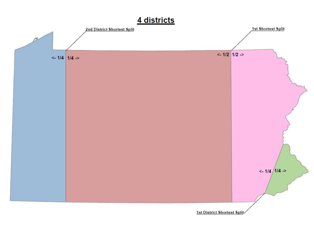
The next map (below) shows PA with four districts. First, draw the shortest possible line that splits the state into two sections, each having ½ the population (the same line as drawn for the two-district case). Next, draw the shortest possible lines that split each of those sections into two districts, each having ¼ of the population.
For any number of districts, just follow the procedure and the required number of equal-population districts will be impartially drawn.
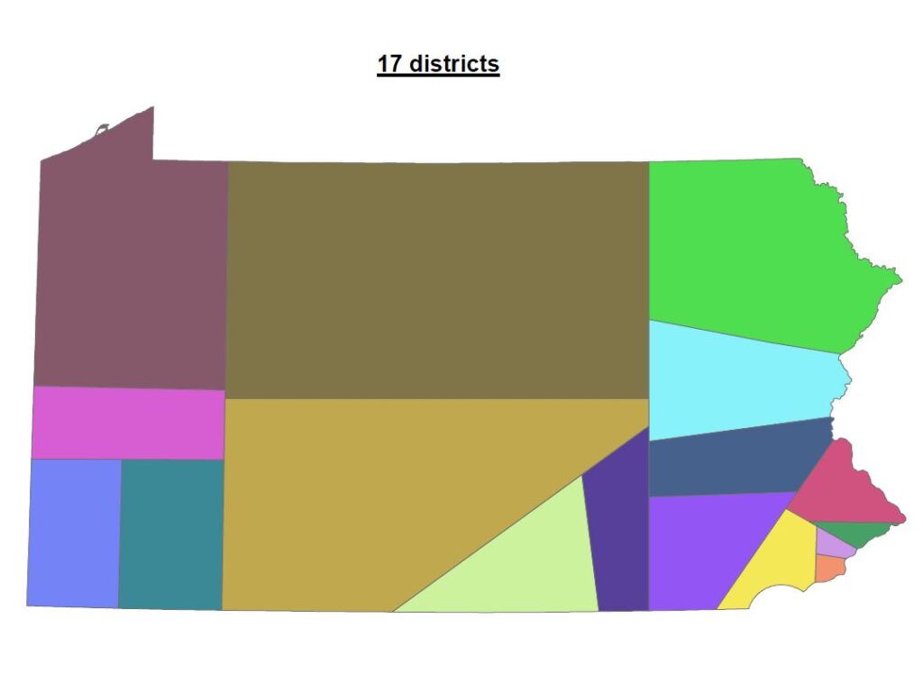
Now that the basic operation of PPS should be clear, we jump to the case of Pennsylvania with 17 districts (map below).

Notice that for 17 districts, the first splitline now divides the state into two sections, one having 8/17 of the population and the other with 9/17 of the population. This is the first step in defining 8 districts to the west of that line and 9 districts on its east side.
Finally, just for pretty, below is a clean map of the 17 district without all the notations.
Drawing straight (geodesic) splitlines can achieve equal population districts extremely accurately. However, preserving the atomicity of voting precincts will inevitably introduce some error in population equality. Is this a problem?
Voting precincts are the smallest political subdivisions. They are normally defined by county governments for the purpose of facilitating and managing voting in elections. Their configuration depends upon the availability, location and size of a polling place that can conveniently service the number of voters in the precinct. This will nominally be from 500 to 2,000 voters. Populations will be somewhat larger since not everyone is a registered voter.
Setting up voting precincts and maintaining them as populations grow and shift over the years and availability of polling locations changes is a lot of work for counties. Chopping up a large number of them at once for a redistricting would be highly disruptive and that is why PPS is designed to avoid it.
The procedure PPS uses to preserve precinct atomicity is designed to be simple, understandable and easy to follow. It also must not stumble when precincts are encountered that are not formed as a single contiguous area. It does attempt to minimize population errors, but an optimal solution in that regard is not guaranteed. Population errors should be less than half the population of the smallest precinct that a splitline divides. Thus, the population error will depend upon the number of precincts contained by the district.
A large district such as a congressional district will contain on the order of 200 precincts. Population errors for districts this large are completely inconsequential. Looking for a worst case, the Pennsylvania House has 203 representatives, requiring very small districts containing nominally 30 precincts. Here, the population errors should be less than plus or minus one percent. As reasoned in Lesson 1, even this worst case should still be quite acceptable.
To summarize the advantages of using PPS for redistricting:
- Draws maximally compact equal-population districts – any number for any state
- Guaranteed to be absolutely impartial (renders gerrymandering impossible)
- Completely eliminates the influence of politicians (indeed, all people) from the process
- Can be done by people or computers
- Completely transparent – anyone anywhere can verify that districts are correctly drawn
- The PPS procedure could easily be amended into US or state constitutions
- PPS provides some weak term-limiting effect as a byproduct
- Turns decennial redistricting into a low-cost non-event lasting about half an hour
Acknowledgements
The basic “splitline” procedure was invented circa 2002 by Warren D, Smith.
The Precinct-Preserving Splitline procedure was independently invented by Roy Minet circa 2009. PPS employs basically the same underlying “splitline” process but includes the precinct-preservation feature.
The map work was graciously contributed by a GIS professional who wishes to remain anonymous. His contribution is nevertheless acknowledged and is greatly appreciated.
Responses